Conflict · Before and after
Khan Younis centre, Gaza
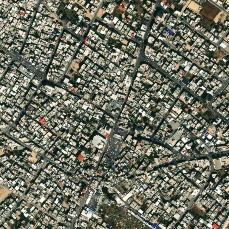
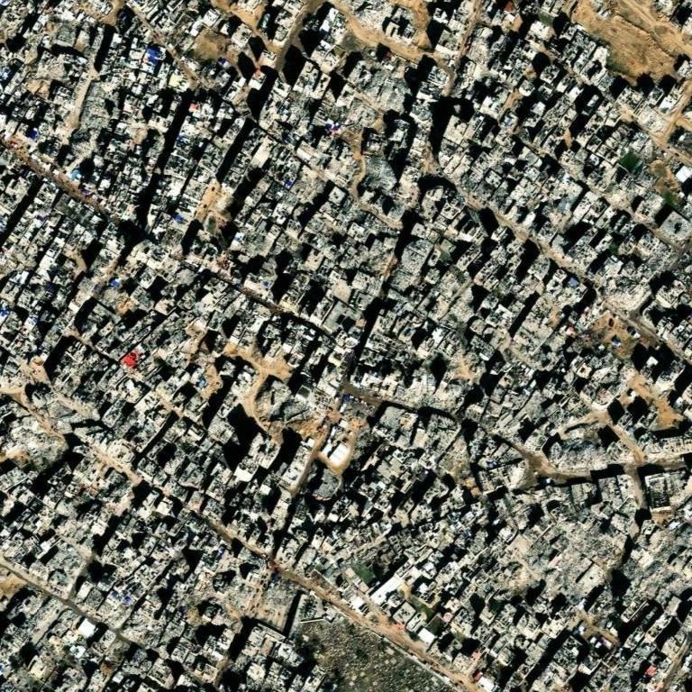
Two dated satellite photos of the same spot, 10 May 2023 and 25 Jan 2025. Open them in GeoWhisperer to swipe between them, check the pair and read what changed.
Open this comparisonCompare another place
What changed
Major change. Widespread destruction of buildings and infrastructure is visible across the entire captured area between May 2023 and January 2025. Piles of light-grey rubble and debris cover former building footprints and road corridors throughout all grid cells.
- Square B2high confidenceDestruction of central white domed building and surrounding multi-story structuresBefore: A prominent white domed building (mosque) surrounded by standing multi-story structures and a paved square with parked cars. After: The domed structure and adjacent buildings are collapsed, replaced by mounds of light-coloured rubble and cleared debris.
- Square A1high confidenceWidespread building collapse and rubble accumulationBefore: Dense residential blocks with intact rooftops and narrow street layout. After: Most structures across the cell are reduced to piles of light grey debris, obscuring street boundaries.
- Square A2high confidenceDestruction of urban building blocks along the roadwayBefore: Dense multi-story structures bordering a clear diagonal street. After: Buildings on both sides of the road corridor are collapsed into heaps of structural rubble.
- Square A3high confidenceBuilding destruction and ground disturbance in open fieldBefore: Intact built-up area adjacent to an open brown soil lot in the upper right. After: Buildings are flattened into grey debris, and the open lot shows vehicle tracks and ground disturbance.
- Square B1high confidenceExtensive structural damage across residential areaBefore: Dense residential blocks including a distinct small red-roofed structure. After: Piles of structural debris replace intact rooflines across the entire block.
- Square B3high confidenceCollapse of standing buildings into rubble fieldBefore: Intact urban neighborhood with clear rooftops and alleyways. After: Extensive building collapse leaving continuous gray rubble across the cell.
- Square C1high confidenceWidespread structural destructionBefore: Intact urban blocks with clearly defined streets. After: Dense rubble fields cover former building footprints and roadways.
- Square C2high confidenceDestruction of buildings and loss of vegetation on southern groundBefore: Standing structures and an open area with green vegetation along the southern boundary. After: Structures are collapsed into rubble, and the southern vegetated ground is churned and cleared bare.
- Square C3high confidenceExtensive building destruction and debris along street curveBefore: Intact urban area bordering a curved street near the top right. After: Rooftops are missing or collapsed into light grey debris covering the area.
The square is split into nine numbered squares, A1 to C3. The changes above sit in B2, A1, A2, A3, B1, B3, C1, C2, C3.
Differences that are not changes
Things that look different in the two photos but do not mean anything changed on the ground:
- Square A2: Long dark streaks extending across the ground. Not counted: shadow.
- Square B2: Parked cars seen in the May 2023 square are missing in January 2025. Not counted: temporary object.
The photos
| Place | Khan Younis centre, Gaza |
|---|---|
| Coordinates | 31.34440, 34.30300 |
| Before photo taken | 10 May 2023 · 0.5 m per pixel |
| After photo taken | 25 Jan 2025 · 0.5 m per pixel |
| Source | Esri World Imagery Wayback (Esri, Maxar and partners) |
| Category | Conflict |
The movie
GeoWhisperer turns this comparison into a short film with numbered markers: watch or download the MP4.
Check it yourself
- This spot on OpenStreetMap
- Sentinel Hub EO Browser, free satellite archive
- Every dated photo of this spot in the Esri archive
The reading above was produced by GeoWhisperer from these two photos and nothing else. It describes what is visible, never why it happened or who did it, and it can miss things or misread shadows, season and viewing angle. Check every line by eye with the slider in the tool. Another OSINT tool by Henk van Ess, www.digitaldigging.org.
← Jabalia refugee camp, Gaza · Front Street, Lahaina, Maui →